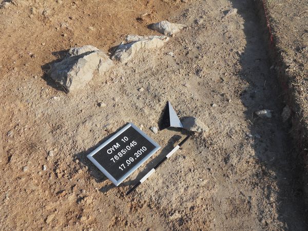
Kontext 7685:045 (Mauer: Wall in northeast corner of excavation unit 7685 (continuation of wall Locus:7785:013 ?)) |
![]() |
Verwaltung |
|
Koordinaten |
![]() |
![]() |
![]() |
Einrichtung
Abschluss |
16.09.2010
|
|
Ost
Nord
Höhe von bis |
7.80 bis 8.90
7.10 bis 8.10
283.99 bis 283.30
|
|
From final report excavation unit 7685 (JE):
"The three stones associated with Locus:7685:045 seem to be related to Locus:7785:013 in excavation unit 7785. This connection is based on the general orientation of Locus:7685:045 . A grayish ?triangle?, referred to as Locus:7685:036 , is deposited against the south face of Locus:7685:045 . Locus:7685:036 may be compared with Locus:7785:023 in excavation unit 7785, which is interpreted as a surface or floor related to wall Locus:7785:013 . Locus:7785:023 reportedly, still, contained Iron Age pottery. If correctly identified as an Iron Age surface, Locus:7685:045 / Locus:7685:036 may be viewed as representing the - stratigraphically - youngest architectural phase in excavation unit 7685."
2011
Wall Locus:7685:045 is related to wall Locus:7785:013 . It is one to two courses high (in square 7685). Moreover, it is assiocated with floor Locus:7685:140 (see Bild no. 17505).
Wall Locus:7685:045 can probably be viewed in conjunction with architectural phase II of the south facade of the central building complex. Associated features/loci are wall Locus:7685:041 , wall Locus:7685:127, plaster Locus:7685:099, floor Locus:7685:112 and floor Locus:7685:140 . More details are available in the final report of the 2011 campaign.
|
| |
| |
| |
| |
|
![]() |
|
| |
![]() |
|
2344 von 3658 |
|
Areal (Jahr) |
alle (alle) |
|
Sortierung |
kontextid DESC |
|
|
| |
![]() |
| |
|
|
Tagesskizzen / Plana |
|
|
| |
Der Locus liegt direkt unter |
![]() |
![]() |
7685:012 (Ablagerung) |
![]() |
|
| |
Der Locus liegt direkt über |
![]() |
![]() |
7685:107 (Versturz) |
![]() |
|
![]() |
|