Tunnel fill, brownish soil with stones, pottery, bones and burnt mud-brick fragments. this locus is below locus 7886-024. This locus is 50 cm long and located below 7886-024.
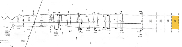
At the bottom are the steps 34 and 35. The steps are cut in the limestone and badly worn out, the steps tilt down towards the room at the end of the tunnel. The height difference between the steps is not a vertical line but a kind of sloping area. The corners between steps and south wall are rounded.
jvzThe south wall stand on the earlier mentioned bed-rock ledge, the north wall on the other hand stands all the way down till on the steps. On the steps the wall is made of small stones on which the large stones are placed. The idea is that this wall is placed on the older existing stairs.
Observation:
"The tunnel as we see it today is not the original structure. It is possible that from the top of the ancient site an open staircase run down towards the ‘room with the doorway’. Or that a larger tunnel existed and it was damaged and it rebuild as a narrower tunnel.
The steps starting from step 32 (counting starts at the highest, first surviving step) and the following lower steps are hewn in the white, soft bedrock. However this bedrock is probably not so soft when newly worked. When exposed to the air and under pressure of the tunnel’s superstructure; the surfaces have crumbled a few centimeters deep.
The steps were hewn with on the south side a connection vertical side, first only a few cm high at step 32, but as it goes down it becomes higher up to about 100 cm.
The lowest stones of the tunnel’s south wall are large stone blocks that are placed directly onto the standing ledge that the standing side of the stairs forms."